West Philippine Sea Tension Part 2

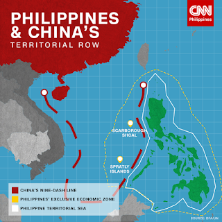
In this blog, I'll try to explain in a simple language the current West Philippine Sea tension started. I do hope I get the facts right. I will show the various reference points and their timeline as sources of the tension. The map below shows the overlapping claim of the Philippines and China in the South China Sea. The red-broken line is China's claim while the yellow-dotted line is the Philippines' claim. Why did this happen? How did this happen? When did all of this start? What are the facts related to this situation? In 1947, Chinese geographer Yan Huairen drew a map of the South China sea. He named each rock and reef and collectively named them as South China Sea islands. That map had been obscure for a long time. The idea surfaced again in 2009 when China presented a map, which is today's nine-dash line, to the United Nations during a territorial water dispute with Vietnam. That made the tension much clearer with us as it runs counter to our claim. On June 11, 1...
